Jonathan Ochshorn
© 2014 Jonathan Ochshorn.

Following is my summary and critique of the USGBC's LEED Building Design & Construction Reference Guide, v4. Commentary on the Reference Guide can be found in these red boxes, sometimes within each of the chapter links immediately above, but also in my summary and critique of the prior versions: Version 2.2 NC and Version 3.0.
The site, in this chapter, is understood as being bounded by the project's property lines, but excluding the building itself. The intention involves "restoring project site elements, integrating the site with local and regional ecosystems, and preserving the biodiversity that natural systems rely on."
Already, one can see the misguided idealism embedded within the LEED guidelines, with respect to ecosystems and biodiversity. It is hard to imagine what the experts at LEED understand the "local and regional ecosystems" to consist of, and how "biodiversity" enters into their calculations. Virtually all urban and suburban areas have been completely severed from their former "natural" state: original forested lands have long since been destroyed; native plant and animal species that formerly lived in a kind of dynamic "balance" (i.e., within various evolving regional ecosystems) have been largely exterminated. To create a guide that asks individual property owners — acting on their own and only within the borders that define their minuscule parcels of land — to integrate with natural ecosystems that no longer exist and create the conditions for biodiversity, is either nonsensical (if the goal is to actually restore the natural ecosystems that preceded modern human settlement), or tautological (if the goal is to create something — anything — that sustains itself). The latter notion of "ecosystem" is tautological since virtually anything can be sustained with a bit of maintenance. As Alan Weisman demonstrates in The World Without Us, such "ecosystems" will quickly disappear without continual human intervention.
Of course, one can attract a few birds, or even build a "constructed wetland" within a single parcel. Such activities are, by definition, ad hoc and ineffectual. Only large-scale planning, not "market-driven" interventions by individual capitalists, can organize human settlement in a manner that accounts for and supports natural ecosystems and biodiversity.
LEED's "Overview" is filled with teleological arguments in which nature is said to be of "service" to humans — "natural capital." Given this bizarre understanding of ecology, it is easy to see how the piecemeal and arbitrary interventions encouraged by the credits in this section are construed as something "sustainable."
Intent: Reduce construction-related pollution related to disruption of soil.
Requirements: Make erosion and sedimentation control plan for the entire construction phase. Conform with EPA 2012 Construction General Permit or local standards (choose more stringent of the two). The 3 issues are: 1) erosion of soil (water or wind); protection of stockpiled topsoil; 2) sedimentation of storm sewers or streams; 3) dust in air. EPA guidelines can be found at: http://cfpub.epa.gov/npdes/stormwater/cgp.cfm
Intent: Evaluate site for sustainable options
Requirements: Create a "survey" of the site that evaluates the following site characteristics:
Topography
Hydrology
Climate
Vegetation
Soils
Human use
Human health effects
Then, explain how the project design takes these site characteristics into account. Explain why any of the issues raised are not addressed or incorporated into the design.
First, it is remarkable that LEED feels it necessary to give projects a point for analyzing the site. Is the presumption that architects would not otherwise examine these issues? Second, the "Behind the Intent" paragraphs are at times both trivial — community gardens should be located "in areas with fertile soils..." — and confusing — if the assessment may be "conducted before or during the conceptual design phase," [emphasis added] how can the assessment possibly "demonstrate the relationships between site features and... how these features influenced the project design..." What's happening here is that the word "assessment" is being used in two different ways: as representing the entire process including the evaluation of the site as well as the relationship of this evaluation to the design; and as representing only the evaluation portion of the prerequisite tasks.
In any case, such assessments presume that the design process operates linearly, with design decisions informed in a straight-forward manner by a site analysis preceding the design. Here's a site feature; there's my design response. What this misses are opportunities for "thinking outside the box": for design to transcend or even contradict existing site features, or for design to create new site features that weren't present before the designer's intervention. It's not as if the LEED prerequisite makes such thinking impossible; rather, the prerequisite reinforces superficial notions of what design consists of, forcing innovative designers to work around its written objectives and methodology.
Intent: Promote biological diversity on site through restoration of damaged sites or conservation of undamaged natural areas.
Requirements: If there is any greenfield area on the site, leave 40% of it undisturbed by either construction activity or actual development. Then, for 2 points (this is "Option 1"): restore 30% of previously developed portions of the site with native/adapted vegetation (except that green roofs that promote biodiversity and habitat while using native/adapted plants can substitute for site area if the project's floor area ratio, or "FAR," is at least 1.5). Or, for only 1 point (this is "Option 2"), give money to a land trust or conservation organization — 40 cents per square foot of total site area.
Because greenfield sites cannot be developed under the Location and Transportation "Sensitive Land Protection" credit, the LEED pragmatists have decided to reward such development in this credit. If it didn't make sense there, does it make sense here? Well, imagine that there are two adjacent sites, one of 100 acres that is entirely greenfield and one of 86 acres that is covered completely with asphalt pavement. If you are an environmentally-sensitive industrial capitalist considering both sites for your factories and looking to get 2 points from this credit, here are your choices: if you choose the greenfield site, you can build on 60 acres (while maintaining greenfield conditions on the remaining 40 acres). If you choose the previously developed site, you can also build on 60 acres (while restoring the other 26 acres). Each site allows the same development area (60 acres), and each provides you with 2 LEED points. In the first case, you are destroying 40 acres of greenfield. In the second case, you are restoring 26 acres of previously developed land with native/adapted plants. So, if you are a very successful industrial capitalist and choose to develop both sites for different projects, you end up tearing up a total of 120 acres for your "green" factories while leaving the planet with less vegetated ground area than you started with. And in doing this, LEED awards you with 2 points for each project.
By the way, nothing changes if there is only one site of 186 acres, of which 100 acres are greenfield. In this case, 60% of the greenfield area (60 acres) can be developed, while 70% of the non-greenfield area (60 acres) can be developed. In the final analysis, 40 acres of greenfield are still being destroyed while only 26 acres of asphalt are being restored — still a net loss of vegetated area that is worth 2 LEED points!
Finally, Green Roof Technology (accessed 6/25/14) has this to say about LEED, green roofs, and biodiversity: "The desperate run for LEED credits didn't stop at green roofs. LEED professionals are inexperienced and they typically count the amount of different species not understanding their interaction with the green roof system and among the plants. Many LEED projects with focus on diversity are going to fail in less than 5 years or their maintenance is not affordable. LEED is counter productive for diverse and successful green roof implementation."
Intent: Create outdoor space to allow humans to interact with "the environment" or with other humans, or to enjoy various types of outdoor activities.
Requirements: At least 30% of the total site area must be accessible outdoor space, of which 5% can be paved or covered with turf grass (the remaining 25% must be vegetated with plantings other than turf grass, or can be covered with an "overhead vegetated canopy" — shrubs or trees — as long as the material on the ground, under the overhead canopy, is not turf grass).
The use of "overhead vegetated canopy" (trees or shrubs) as an alternative to non-turf-grass plantings, is confusing. If it is an alternative ("A minimum of 25% of that outdoor space must be vegetated... or have overhead vegetated canopy"), then one would think that the ground cover below the canopy would not have to be vegetated with non-turf-grass plantings — otherwise, one would not need this listed as an "alternative" since it would already qualify as vegetated open space with or without the canopy. However, the LEED guide specifically excludes turf grass under the canopy, which suggests that hardscape (pavement) would also be prohibited if one wants to count the canopy as "vegetated" open space. That leaves only non-turf-grass plantings as an acceptable ground cover under overhead canopies that are to be counted as vegetated open space, or, in other words, the provision of overhead canopies does not appear to count for anything special.
The open space must be useful in a way approved by LEED: paving or turf to accommodate "social" or "physical" activity; gardens that are visually interesting or able to produce food; or habitat satisfying the "Protect or Restore Habitat" credit previously discussed, i.e., greenfield or native/adapted planting.
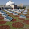
Accessible green roofs can count as open space for projects with a floor-area-ratio (FAR) of at least 1.5. But unlike the prior credit where a green roof must support biodiversity and support native/adapted plants, the "vegetated" roof used for this credit can apparently be entirely paved (as part of the 5% allowed outdoor paved area) and need not support biodiversity — the vegetation can be either intensive or extensive, and need not consist of native or adapted species. However, turf grass cannot be used for the "vegetated" part of a green roof.
LEED explains this credit ("Behind the Intent") by listing the human and environmental benefits of open space, including "linked habitat corridors in urban areas" and "reduced heat island effect." It is a bit puzzling how "linked habitat corridors" will emerge when open space is arbitrarily assigned within privately-owned parcels of land, and is even placed on roofs with no connection (in most cases) to the ground. In fact, one might surmise from the evidence that the LEED guidelines encourage exactly the opposite: non-linked and random open space interventions that cannot encompass any terrain outside the owner's parcel of land. The alleged benefit of "reduced heat island effect" will be discussed within the subsequent SS credit that specifically rewards such reductions.
Intent: Make the developed site work like the undeveloped site in terms of stormwater/hydrology: reduce or eliminate pollution and contaminants from runoff; increase infiltration of water on site.
Requirements: There are two options, only one of which can be used:
Option 1 (for 2-3 points): Manage the site runoff such that it mimics the natural site hydrology to the extent possible for either the 98th percentile of regional/local rainfall events (for 3 points), the 95th percentile (for 2 points), or the 85th percentile (for 3 points but only for urban zero lot line, 1.5 FAR minimum, projects).
Option 2 (for 3 points): Manage the annual increase in site runoff on site.
The requirements for Option 1 are misleading, as they only require that runoff that occurs with the existing (natural) site hydrology be matched for the postdevelopment conditions, at least for the lowest 95 (or 98) percent of rainfall events. If there is considerable runoff in the predevelopment "natural" state, the implication is that the same amount of runoff is acceptable in the postdevelopment state. However, the "step-by-step" guidance explains that rather than mimic the existing hydrology of the site, the entire calculated runoff from such rainfall events must be eliminated, and the rainwater that otherwise would constitute runoff must be managed "entirely on site."
Option 2 is also a bit confusing, as it requires that site runoff be managed on site, which is, of course, literally impossible (since runoff, by definition, must leave the site; if it's managed on site, it's not runoff). It appears that what Option 2 means to say is that the annual runoff volume must be managed so that postdevelopment runoff is no greater than predevelopment runoff. Actually, "step-by-step" instructions explain that the runoff from a 95th percentile storm in the site's postdevelopment condition cannot exceed the runoff estimated from a 95th percentile storm in the site's "natural" condition (i.e., before any human occupation of the site).
Strangely, it appears to be much easier to use Option 2 to get 3 points than to use Option 1 (98th percentile) to get the same 3 points. In Option 2, one only needs to match the natural hydrology of the site so, for example, a sloping site with lots of natural runoff could be developed with the same large amount of runoff (for 3 points); whereas under Option 1, all of the runoff for virtually all rain events would need to be eliminated — redirected and managed on site — even if the natural (predevelopment) conditions generated a great deal of natural runoff. Option 1 would therefore only be used when the "natural" site hydrology of the site cannot be determined; nevertheless, it is a bit strange to create such an enormous difference in the runoff requirements for the two options.
It should be clarified that surface runoff is not just an artifact of pavement and human development. Rather, it is a natural feature of most landscapes, with a third of all water from rainfall events running over the surface of the land, eventually into streams, rivers, and oceans. The U.S. Geological Survey explains it this way: "When rain hits saturated or impervious ground it begins to flow overland downhill. It is easy to see if it flows down your driveway to the curb and into a storm sewer, but it is harder to notice it flowing overland in a natural setting. During a heavy rain you might notice small rivulets of water flowing downhill. Water will flow along channels as it moves into larger creeks, streams, and rivers... about a third of the precipitation that falls over land runs off into streams and rivers and is returned to the oceans. The other two-thirds is evaporated, transpired, or soaks (infiltrates) into groundwater" [accessed 27 June 2014]. Requiring that all runoff from the overwhelming majority of storms (95th or 98th percentile) be eliminated and that the rainfall that otherwise would result in runoff must be managed on site, per Option 1, is therefore a one-size-fits-all strategy that may well be inappropriate for certain site conditions where there is/was a great deal of natural runoff from the site that is and has been naturally "managed" quite satisfactorily.
Intent: Reduce heat islands to reduce presumably negative impacts on "human and wildlife habitats."
Requirements: There are 2 options, only one of which can be used.
Option 1 (for 2 points): First, two definitions. "Nonroof measures" are things done to reduce the quantity of dark (energy-absorptive) surfaces on the site, but not on the building's roof, that meet any of the following criteria: use plant material, either in vegetated areas, or to provide shade over paved areas; provide shade with "energy-generation systems" such as PV arrays or with any structure at all that has a 3-year aged solar reflectance value no less than 0.28, where solar reflectance — SR — measures reflected solar energy on a scale of 0 (black paint) to 1 (white paint); use pavement with SR no less than 0.28; or use an "open-grid" pavement system.
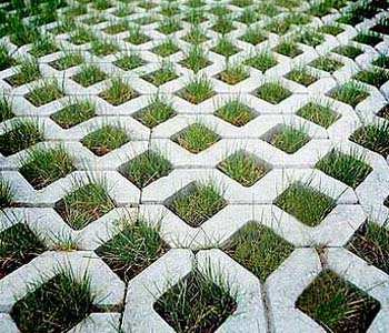
Here is an example of an "open-grid" system — it may not count, however, since LEED requires that the "unbound" materials constitute at least half of the surface area.
High-reflectance roofing is defined in terms of the "solar reflectance index" (SRI) which is measured on a scale of 0 (standard black surface) to 100 (standard white surface). Low-slope (2:12 or less, i.e., less than about 9.5 degrees) roofs need an initial SRI of 82 and a 3-year aged SRI of at least 64; Steep-sloped roofs (greater than 2:12) need an initial SRI of 39 and a 3-year aged SRI of at least 32.
For two points, the area of nonroof measures multiplied by 2, plus the areas of high reflectance roofing and vegetated roof multiplied by 1.333, must be greater or equal to sum of the site paving area and the total roof area.
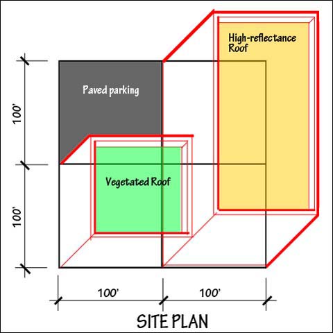
Here is an example of a site measuring 200 ft x 200 ft = 40,000 sq.ft. This site would get two points for heat island reduction based on the following calculation: the dark-toned (parking) area counts for nothing and the area of nonroof measures is zero; however, the area of high reflectance roofing and vegetated roofing equals 30,000 sq.ft. Since 30,000 x 1.333, or 40,000 sq.ft. is greater or equal to the total site area, the criteria is satisfied.
Option 2 (for 1 point): Cover 75% of parking spaces under a roof that satisfies at least one of these criteria: the roof has a 3-year aged SRI of at least 32; the roof is vegetated; or the roof is covered by (or consists of) energy-generating systems such as PV panels.
Option 2 makes very little sense, as can be seen in the illustration pictured below.
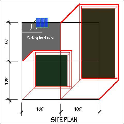
In this example, the site plan is identical to that shown above (for two points under Option 1), except that there are no heat island reduction measures on the roofs. Instead, 3 of the 4 parking spaces are covered with PV panels — a total shaded area of 650 sq.ft. out of the 40,000 sq.ft. site area. Even though the heat island reduction is negligible, the project is awarded 1 point under Option 2.
But all of these criticisms are minor compared to the major flaw in this credit. As I wrote in my Milstein Hall Critique: "It's also not clear that having a light (cool) roof saves energy in this climate... where basically half the year is governed by heating rather than cooling loads. According to the U.S. Department of Energy: 'Your climate is an important consideration when deciding whether to install a cool roof. Cool roofs achieve the greatest cooling savings in hot climates, but can increase energy costs in colder climates due to reduced beneficial winter time heat gains.'" In fact, an article from the November 2013 Construction Specifier concludes that there is a "net loss" in energy savings for all U.S. cities that were modeled, except for Phoenix and Miami, when a "cool roof" is used.
Intent: Reduce light trespass, sky-glow, glare, and impact on nocturnal ecosystems.
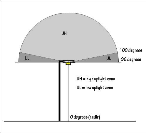
Requirements: There are three separate requirements that must be satisfied under this credit, dealing with uplight (light that is directed above the horizontal), light trespass (light that is directed outside the project site or property lines), and illuminated exterior signage.
Option 1: Using the backlight-uplight-glare (BUG) method, do not exceed the following fixture ratings for uplight only, per IES TM-15-11 Addendum A: UO for LZ0 lighting zone; U1 for LZ1 lighting zone; U2 for LZ2 lighting zone; U3 for LZ3 lighting zone; and U4 for LZ4 lighting zone. The various "U" designations (U0, U1, etc.) define limits to the zonal lumens permitted within the high (UH) and low (UL) uplight regions shown in the diagram below.
The specific limits (zonal lumens) for the various fixture designations are as follows:
| Uplight zone ("secondary solid angle") | U0 | U1 | U2 | U3 | U4 | U5 |
|---|---|---|---|---|---|---|
| UH | 0 | 10 | 50 | 500 | 1000 | >1000 |
| UL | 0 | 10 | 50 | 500 | 1000 | >1000 |
LEED then assigns these fixture limits (U0, U1, etc.) to various lighting zones, as defined by the "Model Lighting Ordinance" promulgated by the International Dark Sky Association. Their five zones (LZ0, LZ1, etc.) are defined as follows:
LZ0: No ambient lighting
Areas where the natural environment will be seriously and adversely affected by lighting. Impacts include disturbing the biological cycles of flora and fauna and/or detracting from human enjoyment and appreciation of the natural environment. Human activity is subordinate in importance to nature. The vision of human residents and users is adapted to total darkness, and they expect to see little or no lighting. When not needed, lighting should be extinguished.
LZ1: Low ambient lighting
Areas where lighting might adversely affect flora and fauna or disturb the character of the area. The vision of human residents and users is adapted to low light levels. Lighting may be used for safety, security and/or convenience but it is not necessarily uniform or continuous. After curfew, most lighting should be extinguished or reduced as activity levels decline.
LZ2: Moderate ambient lighting
Areas of human activity where the vision of human residents and users is adapted to moderate light levels. Lighting may typically be used for safety, security and/or convenience but it is not necessarily uniform or continuous. After curfew, lighting may be extinguished or reduced as activity levels decline.
LZ3: Moderately high ambient lighting
Areas of human activity where the vision of human residents and users is adapted to moderately high light levels. Lighting is generally desired for safety, security and/or convenience and it is often uniform and/or continuous. After curfew, lighting may be extinguished or reduced in most areas as activity levels decline.
LZ4: High ambient lighting
Areas of human activity where the vision of human residents and users is adapted to high light levels. Lighting is generally considered necessary for safety, security and/or convenience and it is mostly uniform and/or continuous. After curfew, lighting may be extinguished or reduced in some areas as activity levels decline.
Option 2: There is an optional "calculation" method to limit uplight which is actually quite different in its objectives from Option 1. Instead of establishing absolute limitations to the amount of light emitted within the uplight zones, Option 2 establishes relative limits, based on a percentage of total fixture light output (except for LZ0 and LZ1, for which no uplight — 0% — is permitted). The uplight limits (light pointing above the horizontal) for the other lighting zones under Option 2 are as follows: 1.5% of total luminaire lumens emitted for LZ2, 3% of total luminaire lumens emitted for LZ3, and 6% of total luminaire lumens emitted for LZ4.
In other words, more uplight is permitted under Option 2 for light fixtures that emit more total light, so that there are actually no limits placed on uplight — the more light emitted by the fixture, the more light is permitted to breach the horizontal and threaten the "dark sky."
Option 1: Again, using the backlight-uplight-glare (BUG) method, do not exceed the following fixture ratings for backlight and glare, per IES TM-15-11 Addendum A:
Allowable backlight ratings
| Fixture mounting | LZ0 | LZ1 | LZ2 | LZ3 | LZ4 |
|---|---|---|---|---|---|
| more than 2 mounting heights from lighting boundary | B1 | B3 | B4 | B5 | B5 |
| 1 - 2 mounting heights from lighting boundary (and oriented properly) | B1 | B2 | B3 | B4 | B4 |
| 0.5 - 1 mounting heights from lighting boundary (and oriented properly) | B0 | B1 | B2 | B3 | B3 |
| less than 0.5 mounting heights from lighting boundary (and oriented properly) | B0 | B0 | B0 | B1 | B2 |
Allowable glare ratings
| Fixture mounting | LZ0 | LZ1 | LZ2 | LZ3 | LZ4 |
|---|---|---|---|---|---|
| more than 2 mounting heights from lighting boundary (building mounted) | G0 | G1 | G2 | G3 | G4 |
| 1- 2 mounting heights from lighting boundary (building mounted) | G0 | G0 | G1 | G1 | G2 |
| 0.5 - 1 mounting heights from lighting boundary (building mounted) | G0 | G0 | G0 | G1 | G1 |
| less than 0.5 mounting heights from lighting boundary (building mounted) | G0 | G0 | G0 | G0 | G1 |
| all other luminaire conditions | G0 | G1 | G2 | G3 | G4 |
The various Bs (B0, B1, B2, etc.) and the various Gs (G0, G1, G2, etc.) are defined in the addendum linked above.
Option 2: There is a "calculation" option which requires that maximum vertical illuminance at the "lighting boundary" (basically the property line) not exceed 0.05 foot-candles (FC) for LZ0 or LZ1, 0.10 FC for LZ2, 0.20 FC for LZ3, and 0.60 FC for LZ4.
There are several exceptions made to the uplight and light trespass limits, the most revealing of which is an exception for "lighting the national flag in MLO lighting zones 2, 3, or 4." Why illuminating a flag justifies an exception to the logic of reducing light pollution is not explained.

From Pinterest: "Solar Powered Flag Light -$59.95- Wave the flag after dark According to the United States Flag Code, you can display the American flag at night if it is properly illuminated. This weatherproof Solar Powered Flag Light has an ultra bright LED lamp that is powered by a 6" x 6" crystalline solar panel. It mounts easily on any flagpole up to 4" in diameter with the included pole mounting bracket, no tools required. Let them see your flag 24 hours a day!"
Such signs must be limited to a maximum illuminance of 200 candela per square meter (cd/m2) at night and 2000 cd/m2 during daylight hours.
First posted 8 July 2014; last updated 10 July 2014